Land and credit as driving forces

DETAILS

Used dataset:

LOKSTAT, POPPKAD

Date:

October 2023

Category:

Doctoral research

LAND AND CREDIT AS DRIVING FORCES

Recently, Nicolas De Vijlder earned his doctorate in History and Business Economics at Ghent University. His dissertation delves into the structural significance of capital in the development of the Southern Low Countries between 1400 and 1900.

Emphasizing the role of land and credit as dominant productive factors, the author explores how the exchange of these forms of capital profoundly influenced society. Market transactions of land and credit were examined in both urban and rural settings, utilizing detailed case studies and macro-analyses. The research highlights the commercialization of the countryside, the growing interconnection between city and rural areas, and the long-term effects of market activities on socio-economic relationships. This study also demonstrates the feasibility and relevance of applying quantitative and econometric research methods to historical issues.

Nicolas De Vijlder based his research in part on datasets from LOKSTAT and POPPKAD, including outcomes from trade and industry censuses.

Publication:

Nicolas De Vijlder, Essays on Land and Credit Markets: The Southern Low Countries 1500-1900. Ghent, PhD Dissertation, 2023.


POPPKAD expands

DETAILS

Used database:

POPPKAD

Date:

January 2022

Category:

Database

POPPKAD expands

The cadastral atlas of P.C. Popp is a first-rate source on real estate and land ownership in the 19th century. The database POPPKAD brings many land register data from this publication within the reach of scientists and interested parties. More than 540,000 landowners from the provinces of Antwerp, Brabant, Hainaut and East Flanders can be found on the projectsite. The site also provides access to images of the land registers in which more information on property owners, buildings and land from the 19th century is brought together. More than 29,000 registers have already been downloaded via this site!

In the course of 2022, the database will be further expanded. Thanks to the tireless efforts of dozens of volunteers, all land register data from the province of West Flanders, as published by Popp between 1843 and 1852, will be added to the database. An estimated 80,000 personal details of real estate owners will be additionally available for consultation via the online search engine. They will be available when data entry and processing are completed. 

The extension of the data collections will be realised in cooperation with the project West Vlaanderen Verpoppt, which has been running since 2019 under the umbrella of Heemkunde West-Vlaanderen.  

Real estate at the service of economic development

DETAILS

Used Database:

LOKSTAT & POPPKAD

Date:

NOVEMBER 2020

Category:

Scientific publication

Real estate at the service of economic development

Nicolas de Vijlder (Department of History UGent) and Koen Schoors (Department of Economics UGent and Higher School of Economics, National Research University Moscow) investigated the factors that have led to the industrialization and economic development of Flanders. They analyzed the development of the economy in most Flemish localities in the period 1830-1910. They explain the regional differences that their analysis reveals with the help of Hernando de Soto’s thesis, which identifies a well-ordered property system as an essential condition for economic development. In regions where real estate generated significant income and was used as collateral for loans, the local economy grew through investment in trade and industry. This pattern is in line with de Soto’s predictions.

The research is based on an extensive analysis of land prices and data on real estate, employment, industry and trade in 1,179 municipalities from LOKSTAT and POPPKAD.


Article:

De Vijlder, Nicolas and Koen Schoors. “Land rights, local financial development and industrial activity: evidence from Flanders (nineteenth–early twentieth century)”.  Cliometrica, 14(2020), 3: 507-50.


Abstract:

In this paper, we investigate the hypothesis that the economic divergence across Flemish localities between 1830 and 1910 is explained by the theory of Hernando de Soto. We hypothesize that the uniform land rights installed after the French revolution provided borrowers with an attractive form of collateral. Conditional on the presence of local financial development provided by a new government-owned bank this eased access to external finance and fostered industrial and commercial economic activity. Using primary historical data of about 1179 localities in Flanders, we find that the variation in the local value of land (collateral) and the variation in local financial development jointly explain a substantial amount of the variation in non-agricultural employment accumulated between 1830 and 1910. By 1910, industrial and commercial economic activity was more developed in localities where both early (1846) rural land prices were high and early (1880) local financial development was more pronounced, which is in line with the ‘de Soto’ hypothesis.

Crisis for whom?

DETAILS

Used database:

LOKSTAT & POPPKAD

Date:

February 2020

Category:

Scientific publication

Crisis for whom?

In the 1840s, Belgium was in the grip of an economic and social crisis. Esther Beeckaert and Eric Vanhaute (History Department, Ghent University) devote a chapter to this serious crisis in the book “An economic history of famine resilience” (Routledge 2019). They describe the crisis in its magnitude and complexity and show how strongly the consequences differed between regions. They then come to an explanation for the varying impact of the crisis. Their findings are largely based on data from population and agriculture censuses that the Quetelet Center has compiled for them. In addition, employees of the Center produced important maps for this research and the publication.

Summary:

In this paper, Esther Beeckaert and Eric Vanhaute make a regional comparison to understand the divergent impact of the 1840s potato famine in Belgium. This famine resulted from successive harvest failures in 1845 and 1846. Initially a potato blight destroyed 87 percent of the harvest and the next year the grain harvest was also partly damaged due to bad weather conditions. The authors start from the observation that the mortality rates were much higher in Inner-Flanders (Kortrijk, Roeselare, Tielt) than in Walloon Brabant (Nivelles), the Campine (Turnhout) and the Ardennes (Neufchâteau). They explain the regionally different impact on the basis of two basic characteristics of rural societies: secure and stable household access to land and performant local redistributive mechanisms through extended labour networks or public poor relief systems. In the Campine and the Ardennes considerable numbers of households were able to survive supported by systems of common access to public land. In Walloon-Brabant these common lands had largely disappeared by then, but impoverished families were relatively successfully sustained by local poor relief institutions and employed by large farms in the region. In contrast, in Inner-Flanders these safety nets were largely absent by the 1840s. Subsistence means from land and labour of many households have been reduced in the years preceding the crisis and the local poor relief institutions were not capable to meet the growing needs.  


Beeckaert, Esther and Eric Vanhaute. “Whose famine? Regional differences in vulnerability and resilience during the 1840s potato famine in Belgium.” In: Jessica Dijkman and Bas van Leeuwen (eds.) An economic history of famine resilience. Routledge, 2019: 115–41.  


Murderous prices

DETAILS

Used database:

LOKSTAT & POPPKAD

Date:

August 2019

Categorie:

Scientific publication

MURDEROUS PRICES

The crisis that hit hard parts of Flanders in the 1840s was the result of a long development and a combination of various factors. Historians blame the depression on the decline of the cottage industry, social inequality, high population pressure, fragmentation of land ownership and a series of crop failures. In a contribution to the recently published book “Histoire rurale de l’Europe, XVIe-XXe siècle”, Wouter Ronsijn (Bocconi University of Milan and Ghent University) examines the different causes from a long-term perspective and points to the important role that the prices and wages played in the crisis. Due to the sharp fall in revenues from the outdated linen industry on the one hand and the rise in food prices on the other, many families were no longer able to make ends meet and many ended up in poverty. Wouter Ronsijn bases his findings on an extensive series of figures, including data on agriculture, industry and property relationships from LOKSTAT and POPPKAD.

Article:

Ronsijn, Wouter. “Alternance d’effets de ciseaux dans l’espace rural de la Flandre intérieure, XVIIIe – XIX siècle”, in Histoire rurale de l’Europe, XVIe-XXe siècle, edited by Laurent Herment (ed.), 203-229.  Paris: EHESS, 2019.

500 years of housing rents

DETAILS

Used database:

POPPKAD

Date:

April 2019

Category:

Research report

500 YEARS OF HOUSING RENTS

Thies Lindenthal (University of Cambridge, Department of Land Economy), Matthijs Korevaar and Piet Eichholtz (both from Maastricht University, School of Business and Economics) took a close look at the rental prices of urban housing and set out their findings in a paper for the Real Estate Research Centre in Cambridge. They studied the development of prices in seven major cities (Amsterdam, Antwerp, Bruges, Brussels, Ghent, London and Paris) between 1500 and 2017. For their research, they had access to a collection of unique historical data, including cadastral data and more than 6000 rental contracts from the POPPKAD database.

Apart from temporary fluctuations due to local circumstances, the relationship between housing rents to wages has been more or less constant for centuries. Rental prices clearly rose from 1900 onwards. The increase was more a result of the improvement in the quality of housing than an increase in the rent itself.

Research report:

Lindenthal, Thies, Matthijs Korevaar and Piet Eichholtz. “500 Years of Urban Rents, Housing Quality and Affordability”. University of Cambridge, Department of Land Economy, Working Paper Series, 2019-1, 1–71.

A piece of land for everyone?

DETAILS

Used database

LOKSTAT and POPPKAD

Date:

2017

Category:

Conference paper

A PIECE OF LAND FOR EVERYONE?

Article:

Ronsijn, Wouter. “‘Gaining ground’ in Flanders after the 1840s: access to land and coping mechanisms of (semi-)landless households in Flanders, ca. 1850-1900”, Rural History Conference, 1–35. Leuven, 2017

Abstract: 

“This paper explores whether, as a result of this shifting power balance, rural households in Flanders in the second half of the nineteenth century were literally gaining ground. All scholars see this period as a profound turning point for the Flemish countryside, affecting both rural coping mechanisms and agricultural production methods. […] Up until then, livelihoods in Flanders often combined small-scale farming for one’s own account with wage labour or market-oriented production, although there were regional variations to that pattern. This paper focuses on what happened with access to land, the indispensable condition for the first component. Did access to land increase, as would be consistent with the change of fortunes mentioned above, or did it decrease, as would be consistent with the overall, long-term European trend of rising landlessness? […] The paper reconstructs the extent of landlessness (households without land) and semi-landlessness (households with less than 2 ha of land, the minimum required for subsistence; this includes households without land) in Flanders, and to indicate the factors affecting that extent in the second half of the nineteenth century. It asks how many landless and semi-landless households there were in Flanders, and how access to land fit in with their other activities? The paper focuses on developments in four regions showing divergent patterns: the districts of Veurne, Kortrijk, Sint-Niklaas and Oudenaarde.” 

Welcome to the Quetelet Center website!

DETAILS

Used databases:

LOKSTAT, POPPKAD, STREAM

Date:

August 2017

Category:

Weblaunch

WELCOME TO THE QUETELET CENTER WEBSITE!

bewerkt
We are proud to present our website and the first large-scale quantitative historical databases managed by the Quetelet Center!

LOKSTAT

LOKSTAT is a database of local and regional statistics in Belgium from the period 1800-1970. The data collections are based on official censuses of the population, agriculture, trade and industry. Data series from other historical sources, such as election results, also appear in the database. Using the cartographic module HISGIS, the data can be presented on a map and analysed in detail.

POPPKAD

POPPKAD brings together data on property and opens up this information about land ownership for scientific research. The data infrastructure is based on the land registry, which has kept an inventory of real estate in Belgium since 1834. The database contains statistics on land use, land ownership and housing at national level (1834-1961). It also includes property data per owner for different regions and places.

STREAM

The STREAM database contains an extensive and diverse collection of local statistics from the early modern period (ca. 1500-1815). The data series included are linked to a customised geographic information system that enables comparative research in time and space by linking different datasets to each other and to localities. The Ferraris map (1770-1777) constitutes the primary source. This map was manually vectorised and then compared with current topographical maps to eliminate geometric discrepancies. As a result, one can view a reconstruction of the landscape, housing, boundaries and transport infrastructure as a series of snapshots over time of the area in question.


Follow the news page on our website to keep up to date with the latest publications based on these databases, new datasets and all our other activities!

Grand plans, the cadastral atlas of Belgium

DETAILS

Used database

POPPKAD

Date:

January 2018

Category:

Publication

GRAND PLANS, THE CADASTRAL ALTALS OF BELGIUM

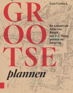
The atlas by P.C. Popp is a commercialised version of the cadastre which brings together different information about property from large parts of the country. It consists of more than 41 000 pages and over 2 300 maps, where buildings, plots and owners are described separately. The publication is one of a kind. There are no publications that can match Popp’s work in terms of scale, wealth of information and level of detail.

Today researchers are grateful for the opportunity to use this unique reference work. If you are looking for solid information about people, buildings, landscapes, housing, agriculture, industry, spatial planning or local history in 19th-century Belgium, then this is the publication for you.

Although the atlas has long enjoyed fame among historians and geographers, the publication is still largely shrouded in mystery. What motivated the creators is a matter of conjecture. Nor is it known why there are no similar reference works in Belgium and its neighbouring countries.

In addition to the history of the publication’s origins, Grootse Plannen also contains a detailed description of the atlas itself. All 1 735 of the issues published are described individually in the book and (often for the first time) dated. Moreover, Grootse Plannen gives a methodological explanation of house research with the help of Popp’s atlas.

The POPPKAD database, which is managed by the Quetelet Center, also opens up access to the extensive reference work of P.C. Popp.

Would you like to start working with this data yourself? Then be sure to consult the POPPKAD page.

Sven Vrielinck
Amsterdam University Press
Hardback,
164 pages,
ISBN 978 94 6298 785 2
Price: 29,99 €

Order:

POPPKAD in demand

DETAILS

Used database:

POPPKAD

Date:

February 2019

Category:

Database

POPPKAD, the database of the Belgian cadastre from the 19th century, is reaching a wide audience. According to the latest usage statistics, more than 3 000 researchers, local historians, genealogists and interested parties have used POPPKAD. Hundreds of them even consult the research infrastructure on a regular basis. In particular, the database of property owners from the mid-19th century is being heavily consulted. The names of 540 000 owners in more than 1000 Belgian municipalities can be searched on the POPPKAD website. The search queries are headed by – somewhat predictably –  the surnames Peeters, Janssens and Desmet. The website also provides access to scans of the original cadastral registers, which combine more information about property owners, buildings and land in the 19th century. According to preliminary figures, more than 15 000 registers have already been downloaded through the website.

A green revolution in the 18th century?

DETAILS

Used database:

POPPKAD

Date:

October 2018

Category:

Publication

A GREEN REVOLUTION IN THE 18TH CENTURY?

Read the full article or consult the POPPKAD website.

Article:

De Graef, Pieter. “A Green Revolution from below? A social approach to fertiliser use in eighteenth-century Flanders”. Continuity and Change 32, no. 3 (2017): 379–410.

Abstract:

“Profound changes in output and productivity characterised eighteenth-century agriculture, both in regions of large-scale capitalist farming and smallholding cultivation. Aggregate, macro-level studies offer valuable insights, but often prove unable to explain yield increases. Therefore, this article proposes a social approach to agricultural production through a micro-level analysis of fertilisation strategies, taking the smallholding economy of inland Flanders as a starting point. The household perspective demonstrates that a green ‘fertiliser’ revolution with increasing levels of fertilising intensity and off-farm nutrient inputs was instigated from below on both small and large holdings as a response to the broader economic and societal situation.”

Organic urban waste as fertiliser in agriculture

DETAILS

Used database:

LOKSTAT & POPPKAD

Date:

2017

Category:

Scientific publication

ORGANIC URBAN WASTE AS FERTILISER IN AGRICULTURE

In his article, Pieter De Graef questions the historical examples of closed cradle-to-cradle systems, which are put forward by ecological historians as forerunners of current closed nutrient cycles. By using agricultural censuses and cadastral statistics from the LOKSTAT and POPPKAD databases, he calculated how much fertiliser was produced in the different regions of Belgium and shows that there were no closed nutrient cycles.

Article:

De Graef, Pieter. “Food from country to city, waste from city to country: an environmental symbiosis? Fertiliser improvement in eighteenth-century Flanders”. Journal for the History of Environment and Society 2 (2017): 25–61.

Abstract:

“Alternative approaches to resolve bottlenecks in food production often champion the reuse of urban organic waste as fertiliser in agriculture in order to close the nutrient cycle between city and country (cradle to cradle). References are often made to the past because environmental historians tend to work the use of urban wastes into a story of environmental symbiosis between city and countryside. This article argues, however, that closed nutrient cycles did not exist even in pre-industrial society, as the way in which agriculture was structured had a huge impact on the demand for manure. Starting from two agricultural regions in eighteenth-century Flanders, this research calls for more attention to regional structures of agriculture in which cities were embedded and to how these agro-systems shaped nutrient flows from the city to the country by very diverse patterns of demand for fertilisers, leading to unequal redistributive flows of nutrients from towns to different agricultural regions.”

Culling the herds

DETAILS

Used database:

POPPKAD

Date:

November 2018

Category:

Scientific publication

CULLING THE HERDS

In their article entitled “Culling the herds”, Adam Sundberg and Filip Van Roosbroeck compared government measures against the rinderpest outbreak of 1769-1785 in the Austrian and the Northern Netherlands. The researchers calculated the mortality rate of the livestock in both regions based on, among other things, statistics on land use from the POPPKAD database. According to the authors, the different socio-ecological structures and the divergent practices in commercial agriculture played a more important role in the spread of the disease than the policies implemented by the different governments.

Article: 

Van Roosbroeck, Filip, and Adam Sundberg. “Culling the herds? Regional divergences in rinderpest mortality in Flanders and South Holland, 1769-1785”. TSEG/The Low Countries Journal of Social and Economic History 14, no. 3 (2018): 31–55. 

Abstract:

“The cattle disease rinderpest devastated Europe throughout the eighteenth century. The practice of preventative slaughter, or stamping out, has been seen as the most effective method of containing the disease. Historians frame this strategy as a measure of the effectiveness of centralized bureaucracy in handling epidemic outbreaks. The Austrian Netherlands, which enacted a stamping out policy during the rinderpest epidemic of 1769-1785, is often cast opposite the decentralized Dutch Republic, which did not. That mortality was more severe in Holland than in Flanders is interpreted as a consequence of this difference. This article compares the disease management of Flanders and South Holland as well as the differential mortality of cattle in the initial years of the outbreak. We argue that stamping out should not be used as the standard for evaluating effective management. Both South Holland and Flanders relied on a high degree of state intervention. No strategies were universally effective. Explanations must be sought in regional socio-ecological structures. Rather than a consequence of state action or inaction, rinderpest mortality responded to the movement of cattle for pasturing and trade, structural differences in land use, and the resultant divergences in agricultural practices and herd management. Rather than state intervention, extensive commercial cattleholding explains the highly variable mortality.”